Title 40 CFR Part
191
Subparts B and C
Compliance Recertification
Application
for the
Waste Isolation Pilot Plant
Content of
Compliance
Recertification Application(s)
(40 CFR § 194.15)
United States Department
of Energy
Waste Isolation Pilot Plant
Carlsbad Field Office
Carlsbad, New Mexico
Content of Compliance
Recertification Application(s)
(40 CFR § 194.15)
15.0 Content of Compliance Recertification Application(s) (40 CFR § 194.15)
15.3 1998 Certification Decision
15.5 EPA’s Evaluation of Compliance for the 2004 Recertification
15.6 Changes or New Information Since the 2004 Recertification
15.6.1.2 Geophysical Information
15.6.1.3 Geochemical Information
15.6.1.4 Hydrologic Information
15.6.1.4.2 Recent Hydrological Investigations
15.6.1.5 Meteorological Information
15.6.3.1 WIPP Repository Conditions, Chemistry, and Processes
15.6.3.2 MgO Studies and Characterization
15.6.3.3 Actinide Investigations
15.6.4.1 Status of Underground Excavation
15.6.4.2 Remote-Handled Transuranic Waste Emplacement
15.6.4.3 Proposed RH-TRU Waste Container Modifications
15.6.4.4 Neutrino Experiments in the WIPP Underground Repository
15.6.5.1 Status of Waste Emplacement
15.6.5.2 Waste Characteristics and Components Important to Demonstration of Compliance
Figure 15-1. Monthly Precipitation for the WIPP Site, 1990–2006
Figure 15-2. 2003 Annual Wind Rose at 10-m (33-ft) Height at the WIPP Site
Figure 15-3. 2004 Annual Wind Rose at 10-m (33-ft) Height at the WIPP Site
Figure 15-4. 2005 Annual Wind Rose at 10-m (33-ft) Height at the WIPP Site
Figure 15-5. 2006 Annual Wind Rose at 10-m (33-ft) Height at the WIPP Site
Figure 15-6. Status of Mining and Waste Emplacement as of October 1, 2007
Table 15-2. Seismic Events in the Delaware Basin
Table 15-3. Annual Average, Maximum, and Minimum Temperaturesa
ACR Annual Change Report
ASER Annual Site Environmental Report
CARD Compliance Application Review Document
CCA Compliance Certification Application
CH-TRU contact-handled transuranic
COMP compliance monitoring parameter
CRA Compliance Recertification Application
DBDSP Delaware Basin Drilling Surveillance Program
DOE U.S. Department of Energy
DOT U.S. Department of Transportation
DRZ Disturbed Rock Zone
EPA U.S. Environmental Protection Agency
EXO enriched xenon observatory
ft foot/feet
GAR Geotechnical Analysis Report
high-T high-transmissivity
in inch
km kilometer
LANL Los Alamos National Laboratory
LWA Land Withdrawal Act
MEGA multiple element germanium array
mi mile
mm millimeters
NE northeast
NMIMT New Mexico Institute of Mining and Technology
PA performance assessment
PABC performance assessment baseline calculation
RH-TRU remote-handled transuranic
SEGA segmented enriched germanium assembly
SNL Sandia National Laboratories
SPDV Site and Preliminary Design Validation
SSW shallow subsurface water
SW southwest
TDS total dissolved solids
TRU transuranic
WIPP Waste Isolation Pilot Plant
Am americium
MgO magnesium oxide
Nd neodymium
Pu plutonium
U uranium
|
§ 194.15 Content of Compliance Recertification Application(s) (a) In submitting documentation of continued compliance pursuant to section 8(f) of the WIPP LWA, the previous compliance application shall be updated to provide sufficient information for the Administrator to determine whether or not the WIPP continues to be in compliance with the disposal regulations. Updated documentation shall include: (1) All additional geologic, geophysical, geochemical, hydrologic, and meteorological information; (2) All additional monitoring data, analyses and results; (3) All additional analyses and results of laboratory experiments conducted by the Department or its contractors as part of the WIPP program; (4) An identification of any activities or assumptions that deviate from the most recent compliance application; (5) A description of all waste emplaced in the disposal systems since the most recent compliance certification or re-certification application. Such description shall consist of a description of the waste characteristics and waste components identified in § 194.24(b)(1) and § 194.24(b)(2); (6) Any significant information not previously included in a compliance certification or re-certification application related to whether the disposal system continues to be in compliance with the disposal regulations; and (7) Any additional information requested by the Administrator or the Administrator’s authorized representative. (b) To the extent that information required for a re-certification of compliance remains valid and has been submitted in previous certification or re-certification applications(s), such information need not be duplicated in subsequent applications; such information may be summarized and referenced. |
Information documented in the 2009 Compliance Recertification Application (CRA-2009) is prescribed in 40 CFR § 194.15 (U.S. Environmental Protection Agency 1996). These documentation requirements parallel the requirements of 40 CFR § 194.14 (U.S. Environmental Protection Agency 1996), which apply primarily to the Compliance Certification Application (CCA) (U.S. Department of Energy 1996), the original application. The focus of section 194.15 is to ensure that CRAs include documentation regarding any changes to the disposal system that may have occurred since the previous certification or recertification. Updated information regarding relevant aspects of the waste and the disposal system is documented. However, in cases where information and assumptions have not changed, no new information need be documented; the CRA-2009 may reference or summarize such unchanged information.
The CRA-2009 must identify relevant systems and program changes implemented during the preceding five-year period. Any activity or assumption that deviates from what was described in the most recent compliance certification or recertification application would be considered a change. The CRA-2009 also documents changes reviewed and approved by the U.S. Environmental Protection Agency (EPA) in the preceding five-year period (through modification of the certification or other processes). The CRA-2009 documents instances where new baseline program elements were established as a result of changes.
The CCA, Chapters 2.0 and 3.0 and Appendices GCR, HYDRO, and MASS, include general information about the Waste Isolation Pilot Plant (WIPP) site and disposal system design. Other site characteristics, design, location, and construction information is primarily provided in the CCA, Chapter 7.0 and Appendices BACK, DEL, PCS, and SEAL. After its review, the EPA concluded that the U.S. Department of Energy (DOE) adequately addressed the geology, geophysics, hydrogeology, hydrology, meteorology, climatology, and effects of waste and geochemistry of the disposal system and its vicinity, and how these conditions are expected to change and interact over the regulatory time frame (Compliance Application Review Document [CARD] 14, U.S. Environmental Protection Agency 1998a). The EPA reviewed the DOE’s CCA and additional information submitted by the DOE and determined that the DOE complied with each of the criteria of section 194.14. A complete description of the EPA’s 1998 Certification Decision for section 194.14 can be found in U.S. Environmental Protection Agency 1998b, as well as CARD 14 (U.S. Environmental Protection Agency 1998a).
Baseline documentation for section 194.14 was established at the time of the original EPA certification. Information on changes to section 194.14 topics that occurred since the original certification is required to be documented by section 194.15. Changes that occurred during the five-year period following the original certification are documented in the CRA-2004 (U.S. Department of Energy 2004a), which was submitted by the DOE and reviewed by the EPA under the requirements of section 194.15.
During public review of the CRA-2004, the EPA received comments regarding karst features, vertical fracturing, and transport through the Magenta. The EPA assessed these comments and concluded that DOE has demonstrated continued compliance. The EPA responses to comments on the CRA-2004 are documented in CARD 14/15, Appendix 15-A (U.S. Environmental Protection Agency 2006a).
Based on a review and evaluation of the CRA-2004 and supplemental information provided by the DOE (available for review in EPA Docket A-98-49), the EPA determined that the DOE continued to comply with the disposal standards (U.S. Environmental Protection Agency 2006b).
To document that the WIPP continues to comply with the disposal standards in each five-year recertification cycle, changes and new information since the previous recertification must be described. Changes and new information since the CRA-2004 related to section 194.15 are either described below, or references are provided to other sections or appendices of the CRA-2009 that provide the necessary material.
Much of the information provided in this section was obtained from routinely published reports. Table 15-1 lists these reports and summarizes the type of information contained in each.
|
Description |
Summary |
Frequency |
Referencea |
|
Annual Site Environmental Report (ASER) |
Describes compliance status with applicable federal regulations and environmental monitoring performed during the year at the WIPP. Highlights any significant monitoring results or findings. |
Annual |
|
|
Geotechnical Analysis Report (GAR) |
Reports data related to the geotechnical performance of the various underground facility components, including the shafts, shaft stations, access drifts, and waste disposal areas. Volume 1 describes the overall program; Volume 2 provides a compilation of the collected data. |
Annual |
|
|
Annual Change Report (ACR) (194.4(b)(4) b Report) |
Provides information each year on any change in conditions or activities related to the disposal system, as required by 40 CFR § 194.4(b)(4). The majority of the items reported are inspections, reports, and modifications to written plans and procedures. In addition, the ACR provides updates on waste volumes of several parameters and radionuclides upon which the EPA imposes limits. |
Annual |
|
|
Delaware Basin Drilling Surveillance Report |
Lists changes in drilling including rates for shallow and deep drilling; pipeline activity; borehole plugging; injection wells; potash, sulfur, and solution mining; and any other new activity related primarily to human intrusion. |
Annual |
|
|
Compliance Monitoring Parameters (COMPs) Report |
The DOE uses PA to simulate the expected long-term performance of the WIPP. COMPs are used to indicate conditions that are not within expected PA data ranges or conceptual model assumptions, and to alert the project to unexpected conditions. Examples of COMPs include waste activity, changes in groundwater conditions, and creep closure rate. |
Annual |
|
|
Subsidence Monument Leveling Survey |
Survey includes determination of the elevation of each of the existing subsidence monuments and the WIPP baseline survey, and of the National Geodetic Survey’s vertical control points. |
Annual |
|
|
Biennial Environmental Compliance Report |
As required by the WIPP Land Withdrawal Act (LWA), this document reports the status of the project’s compliance with a variety of environmental protection laws and regulations. |
Biennial |
|
|
aThe entry in this column is the most recent report available. |
|||
40 CFR § 194.15(a)(1) requires the submittal of “all additional geologic, geophysical, geochemical, hydrologic, and meteorological information.” Information responding to this requirement is provided in the following sections.
New geologic information has been developed since the preparation of the CRA-2004, and is provided in Appendix HYDRO-2009. Geologic studies between 2003 and 2007 focused on Rustler Formation halite margins and karst. The map of Rustler halite margins delineated by Powers (2002) for the CRA-2004 was revised by Powers (2007) to incorporate data from recent drilling near the WIPP site. Lorenz (2006a and 2006b) reviews historical data and arguments on karst at the WIPP. Lorenz (2006b, p. 243) concludes that most of the geological evidence offered for the presence of karst in the subsurface at the WIPP site “has been used uncritically and out of context, and does not form a mutually supporting, scientifically defensible framework. . . . The remaining evidence is more readily interpreted as primary sedimentary features.” Powers et al. (2006) provide new details on the gypsum karst present in the Rustler of Nash Draw. Powers (2006a) studies some of the natural brine lakes in Nash Draw, finding some of them to be fed by a shallow gypsum karst system with enough storage to sustain year-round flow, while others were fed by the potash-processing effluent discharged by Mosaic Potash Carlsbad into Laguna Uno. Powers (2006b) also maps closed catchment basins in the SW arm of Nash Draw that drain internally to karst features.
Regional seismic activity has been the focus of ongoing geophysical investigations since the development of the CRA-2004. Regional seismic activity is monitored to establish a basis for predicting ground motions that the WIPP repository may experience in both the near and distant future. Historic seismic monitoring data are divided into two categories: pre- and post-instrumentation. Prior to 1962, instrumented seismic monitoring stations did not exist in New Mexico; information about seismic activity was derived from qualitative sources, such as reports of effects on people, structures, and surface features. Since 1962, seismograph coverage for New Mexico has become sufficiently comprehensive to locate regional epicenters. As would be expected, after the installation of the monitoring network, the number of reported events increased. Recorded events include natural seismic events as well as those resulting from human activities.
In the early 1990s, to increase coverage in the vicinity of the WIPP, the New Mexico Institute of Mining and Technology (NMIMT) installed a network of seven seismograph stations in southeastern New Mexico. These instruments are sufficiently sensitive to detect events with magnitudes as low as 0.1 on the Richter scale. This further increased the number of seismic events recorded in the area.
Starting in January 1997, a large number of seismic events were concentrated in an area known as Dagger Draw, northwest of Carlsbad, New Mexico, and near the Dagger Draw gas field, suggesting that the events may be induced by natural gas production activity. In 2003, two more seismograph stations were located in the vicinity of Dagger Draw to allow the recording of smaller events that could not previously be detected. Although the number of recorded events increased dramatically in this area, peaking in 2004, almost all of the recorded events are of low magnitude.
Information regarding seismic events is generally recorded in catalogs, which are divided into categories based on the magnitude registered for each event. Most catalogs have a section detailing seismic events with a magnitude greater than 3.0 because this is the point at which seismic events can be felt.
The NMIMT has recently generated comprehensive catalogs incorporating new programs for locating the epicenter and defining the magnitude of seismic events. NMIMT then regenerated information from the old catalogs using the new programs. For some past events, both the recorded magnitude and epicenter changed, while in others, either the magnitude or the epicenter changed.
The WIPP Delaware Basin Drilling Surveillance Program (DBDSP) tracks seismic events occurring in the vicinity of the WIPP Site. In 2007, the DBDSP completed the update of its seismic database, incorporating the changes and adding events that were not previously considered in the area.
During the current CRA-2009 monitoring period (October 2002 through September 2007), there were 703 seismic events recorded within approximately 240 kilometers (km) (150 miles [mi]) of the WIPP site. Almost all (85%) of the recorded events occurred in the Dagger Draw area of Eddy County. Nearly all of these events were of a magnitude that would not be felt by humans.
Although the DBDSP collects information on areas outside of the Delaware Basin, such as Dagger Draw, the Delaware Basin is used as the defining area for data collection and input to PA. The number of recorded events that have occurred within the Delaware Basin between 1971 and September 2007 (the CRA-2009 cutoff date) are listed in Table 15-2, Seismic Events in the Delaware Basin.
A map showing the locations of 87 seismic events that have occurred within 240 km (150 mi) of the WIPP with a reported magnitude greater than 3.0 is provided in Appendix DATA-2009, Section DATA-2.2. Of these 87 events, only 4 occurred in the Delaware Basin. The one closest to the WIPP site occurred as a result of a roof fall in one of the local potash mines (U.S. Department of Energy 2007a).
Although an increased number of seismic events has been recorded, no significant or anomalous seismic events have occurred in the vicinity of the WIPP since the CRA-2004.
New hydrogeochemical information has been
collected since the CRA-2004. This new information is
described in detail in Domski and Beauheim (2008) and in Appendix
HYDRO-2009. Extensive groundwater sampling has been
performed in new wells and selected older wells. The last
major geochemical evaluation of Culebra groundwater was performed
by Siegel, Lambert, and Robinson (1991) based on samples from 22 wells. Samples are now
available from 59 wells, allowing refinement of the conceptual
understanding provided by Siegel, Lambert, and Robinson
(1991). Whereas Siegel, Lambert, and Robinson (1991)
identify only four hydrochemical facies (A, B, C, and D) based
primarily on ionic strength and major
|
County |
No. of Events |
Earliest Event |
Latest Event |
Smallest Magnitude |
Largest Magnitude |
|
Culberson |
12 |
10/27/1992 |
12/20/2005 |
1.1 |
2.4 |
|
Eddy |
15 |
11/28/1975 |
07/05/2007 |
0.5 |
3.7 |
|
Lea |
1 |
06/23/1993 |
06/23/1993 |
2.1 |
2.1 |
|
Loving |
4 |
02/04/1976 |
04/24/2003 |
1.1 |
2.0 |
|
Pecos |
18 |
01/30/1975 |
12/22/1998 |
1.0 |
2.6 |
|
Reeves |
18 |
02/19/1976 |
05/25/2002 |
1.0 |
3.1 |
|
Ward |
47 |
09/03/1976 |
08/19/1978 |
0.3 |
2.8 |
|
Winkler |
8 |
09/24/1971 |
09/15/1988 |
0.0 |
3.0 |
|
Key: Magnitude Less than 2 Very seldom felt 2.0 to 3.4 Barely felt 3.5 to 4.2 Felt as a rumble 4.3 to 4.9 Shakes furniture; can break dishes 5.0 to 5.9 Dislodges heavy objects; cracks walls 6.0 to 6.9 Considerable damage to buildings 7.0 to 7.3 Major damage to buildings; breaks underground pipes 7.4 to 7.9 Great damage; destroys masonry and frame buildings Above 8.0 Complete destruction; ground moves in waves Source: DBDSP, U.S. Department of Energy 2007c |
|||||
constituents, two transitional facies (A/C and B/C) and one entirely new facies (E) can now be delineated (Domski and Beauheim 2008). The spatial distribution of these facies is consistent with the locations of the Rustler halite margins, the distribution of transmissivity in the Culebra, and the areas of known or suspected recharge to the Culebra.
New piezometers have been installed, and new hydrological investigations have been undertaken since the CRA-2004. Related information is provided below and in Appendix HYDRO-2009.
Shallow subsurface water (SSW) was first detectedat the WIPP site in 1995 when a video inspection of the exhaustshaft showed seepage from about 50 to 80 feet (ft) below the ground surface. The SSW occurs in a perched water-bearing zone above the contact between the Santa Rosa Formation and theupper Dewey Lake Formation.
To evaluate if the Site and Preliminary Design Validation (SPDV) mined tailing pile was contributing to the anthropogenic SSW, piezometers PZ-13, PZ-14, and PZ-15 were drilled in August 2007. This pile has been decommissioned and is no longer used. An engineered cover has been placed on the pile.
Piezometers PZ-13, PZ-14, and PZ-15 indicated saturated sections in all three locations at different horizons, and, in one case, a different formation. Based on data from the piezometers, analysis of water levels, and geological analysis, it is concluded that the water levels identified in PZ-13 and PZ-14 are the result of the SPDV pile runoff or infiltration prior to the installation of the engineered cover. Water in PZ-15 is much more shallow and chemically different from that in the othertwo wells, indicating a different source, such as recharge and infiltration from a topographic depression east of the SPDV pile. A report on this investigation using the new piezometers is provided in U.S. Department of Energy 2008b.
Since the September 2002 data-cutoff date for the CRA-2004, the DOE has collected a significant amount of new information on WIPP hydrogeology, both in response to requests from the EPA and as a result of ongoing monitoring programs. Appendix HYDRO-2009 describes the new information collected as of the end of 2007; a brief summary is provided below.
Hydrological investigations conducted from 2003 through 2007 provided a wealth of new information, some of it confirming long-held assumptions and others offering new insight into the hydrological system around the WIPP site. A Culebra monitoring-network optimization study was completed by McKenna (2004) to identify locations where new Culebra monitoring wells would be of greatest value and to identify wells that could be removed from the network with little loss of information. Eighteen new wells were completed, guided by the optimization study, geologic considerations, and/or unique opportunities. Seventeen wells were plugged and abandoned, and two others were transferred to the U.S. Bureau of Land Management.
The WIPP groundwater monitoring program has augmented monthly water-level measurements with continuous (nominally hourly) fluid-pressure measurements using downhole programmable TROLL® pressure gauges in all Culebra wells except for the Water Quality Sampling Program wells. The most significant new finding arising from the continuous measurements has been the observation of Culebra water-level responses to rainfall in Nash Draw. The Culebra has long been suspected of being unconfined in at least portions of Nash Draw because of dissolution of the upper Salado, subsidence and collapse of the overlying Rustler, and karst in Rustler gypsum units (Beauheim and Holt 1990). However, continuous monitoring with TROLL® gauges has provided the first direct evidence of Culebra water levels responding to rainfall. Furthermore, the rainfall-induced head changes originating in Nash Draw are now observed to propagate under Livingston Ridge and across the WIPP site over periods of days to months (Hillesheim, Hillesheim, and Toll 2007), explaining some of the changes in Culebra water levels. Other water-level changes that appear to occur quite suddenly can now be conclusively related to drilling of nearby oil and gas wells.
Extensive hydraulic testing has been performed in the new wells (Appendix HYDRO-2009). This testing has involved both single-well tests, which provide information on local transmissivity and heterogeneity, and long-term (19 to 32 days) pumping tests that have created observable responses in wells up to 9.5 km (5.9 mi) away. The transmissivity values inferred from the single-well tests (Roberts 2006 and 2007) support the correlation between geologic conditions and Culebra transmissivity developed by Holt and Yarbrough (2002) and elucidated by Holt, Beauheim, and Powers (2005). The types of heterogeneities indicated by the diagnostic plots of the pumping-test data are consistent with the known spatial distribution of transmissivity in the Culebra. Mapping diffusivity values obtained from analysis of observation-well responses to pumping tests shows areas north, west, and south of the WIPP site connected by fractures, and also a wide area that includes a NE-to-SW swath across the middle part of the WIPP site where hydraulically significant fractures are absent (Beauheim 2007). This mapping, combined with the responses observed to the long-term SNL-14 pumping test, has confirmed the presence of a high-transmissivity (high-T) area extending from the SE quadrant of the WIPP site to at least 10 km (6 mi) to the south. Additional information related to this high-T area is discussed in Appendix HYDRO-2009, Section HYDRO-6.4.
Combining the Culebra monitoring data with catchment basin mapping in southwestern Nash Draw and groundwater geochemistry data provides insight into Culebra recharge. While some of the water entering gypsum karst in Nash Draw discharges into brine ponds such as Laguna Cinco, some portion of it must come into hydraulic communication with the Culebra, at least locally, because Culebra wells in Nash Draw show water-level responses to major rainfall events. However, these responses do not mean that the precipitation reached the Culebra. Rather, they indicate that the Culebra cannot be completely confined, but must be in hydraulic communication with a water table in a higher unit that does receive direct recharge from precipitation. Some of this water must eventually reach the Culebra, where it is recognized as the low ionic strength, CaSO4-dominated hydrochemical facies B, but it must first have spent a considerable period in the Rustler gypsum beds to have as high a total dissolved solids (TDS) as it does. As a further indication of the recharge’s indirect nature, the water from SNL-16 (which is located within a small catchment basin in Nash Draw) does not fall in the domain of facies B, but is instead in the higher ionic strength facies C, even though SNL-16 shows a clear pressure response to major rainfall events. This shows conclusively that rainfall is not rapidly flushing the Culebra in this area (Domski and Beauheim 2008).
Lowry and Beauheim (2004 and 2005) conclude from two modeling studies that leakage from units above the Culebra through poorly plugged and abandoned boreholes is a plausible explanation for the long-term rise in water levels observed at and near the WIPP site. The Intrepid East tailings pile may well be the primary source of leaking water north of the WIPP site, while natural recharge where the Culebra is unconfined southwest of the site could provide the leaking water ascribed to a southern borehole by Lowry and Beauheim (2005). The studies showed that a physically reasonable amount of leakage through unconfirmed but realistic pathways is consistent with the observed rising water levels. Greater detail is provided in Appendix HYDRO-2009.
The Meteorological Monitoring Program measures atmospheric data for the WIPP site. This section provides a brief description of the program and updated meteorological data covering the years 2002 through 2006. No anomalous weather events or changes in climatic conditions occurred during 2002–2006.
The primary WIPP meteorological station is located 600.5 m (1,970 ft) northeast of the Waste Handling Building. The main function of the station is to provide data for atmospheric modeling, measuring and recording wind speed, wind direction, and temperature at elevations of 2, 10, and 50 m (6.5, 33, and 165 ft) above ground level, as well as ground-level measurements of barometric pressure, relative humidity, precipitation, and solar radiation.
Information related to recent meteorological conditions is provided below. Data are from the WIPP environmental monitoring reports.
Temperatures are moderate throughout the year, although seasonal changes are distinct. The mean annual temperature in southeastern New Mexico is 17 ºC (63 ºF). In the winter (December through February), nighttime lows average near -5 ºC (23 ºF), and highs average in the 50s (°F). The lowest recorded temperature at the nearest Class A weather station in Roswell was -34 ºC (-29 ºF) in February 1905. In the summer (June through August), the daytime high temperature exceeds 32 ºC (90 ºF) approximately 75% of the time. The National Weather Service documented 50 ºC (122 ºF) at the WIPP site as the record high temperature for New Mexico on June 27, 1994.
The annual average, maximum, and minimum temperatures from 1990 through 2006 are listed in Table 15-3.
Table 15-3. Annual Average, Maximum, and Minimum Temperaturesa
|
Year |
Annual Average Temperature |
Maximum Temperature |
Minimum Temperature |
|||
|
(ºC) |
(ºF) |
(ºC) |
(ºF) |
(ºC) |
(ºF) |
|
|
1990 |
17.8 |
64.0 |
46.1 |
115.0 |
-13.9 |
7.0 |
|
1991 |
17.2 |
63.0 |
42.8 |
109.0 |
-7.8 |
18.0 |
|
1992 |
17.2 |
63.0 |
42.8 |
109.0 |
-10.0 |
14.0 |
|
1993 |
17.8 |
64.0 |
42.8 |
109.0 |
-18.9 |
-2.0 |
|
1994 |
17.8 |
64.0 |
50.0 |
122.0 |
-14.4 |
6.0 |
|
1995 |
17.0 |
63.0 |
42.0 |
107.0 |
-7.0 |
19.0 |
|
1996 |
17.0 |
63.0 |
41.0 |
106.0 |
-7.0 |
19.0 |
|
1997 |
16.3 |
61.4 |
38.6 |
101.5 |
-11.4 |
11.4 |
|
1998 |
18.3 |
64.9 |
41.6 |
106.9 |
-10.8 |
12.6 |
|
1999 |
18.1 |
64.6 |
40.9 |
105.6 |
-7.9 |
17.8 |
|
2000 |
17.4 |
63.3 |
40.2 |
104.4 |
-6.8 |
19.7 |
|
2001 |
17.5 |
63.5 |
39.5 |
103.2 |
-7.8 |
18.0 |
|
2002 |
17.2 |
62.3 |
40.82 |
105.5 |
-10.4 |
13.3 |
|
2003 |
18.1 |
64.6 |
39.2 |
102.7 |
-9.1 |
15.6 |
|
2004 |
16.8 |
62.2 |
38.6 |
101.5 |
-12.0 |
10.4 |
|
2005 |
16.8 |
62.2 |
39.8 |
103.6 |
-13.0 |
8.6 |
|
2006 |
18.3 |
65.0 |
39.6 |
103.3 |
-6.0 |
21.1 |
|
Average |
17.4 |
63.4 |
41.5 |
106.8 |
-10.2 |
13.5 |
|
a Source: WIPP annual Site Environmental Reports for calendar years 2002 through 2006 (U.S. Department of Energy 2003, 2004b, 2005a, 2006b, and 2007a). |
||||||
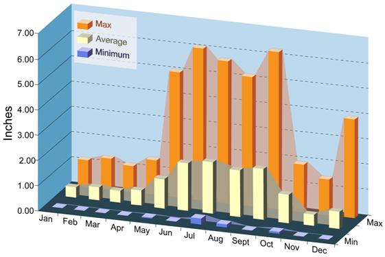
Precipitation is light and unevenly distributed throughout the year, averaging 400 millimeters (mm) (15.7 inches [in.]) per year from 1990 through 2006. Winter is the season of least precipitation, averaging less than 15 mm (0.6 in.) of rainfall per month. Snow averages about 137 mm (5 in.) per year at the site and seldom remains on the ground for more than a day. Approximately half the annual precipitation comes from thunderstorms in June through September. Rains are usually brief, but occasionally intense, when moisture from the Gulf of Mexico spreads over the region. Monthly average, maximum, and minimum precipitations recorded at the WIPP site from 1990 through 2006 are shown in Figure 15-1.
Figure 15-1. Monthly Precipitation for the WIPP Site, 1990–2006
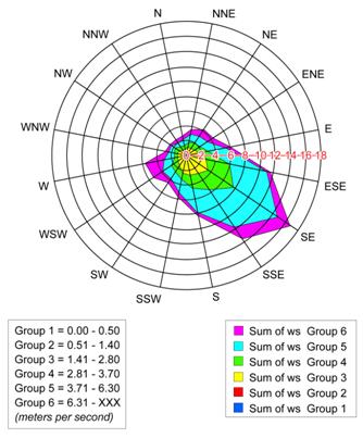
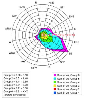
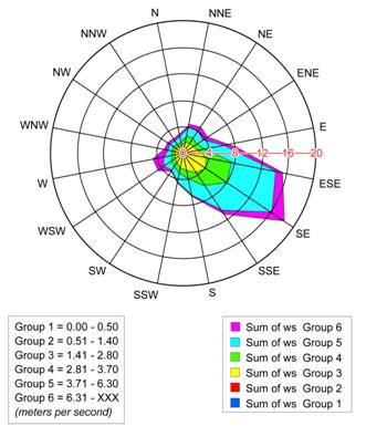
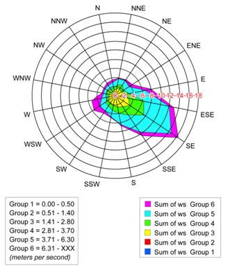
Recent wind roses indicating the frequencies of wind speeds and directions at the WIPP are provided as Figure 15-2, Figure 15-3, Figure 15-4, and Figure 15-5.
40 CFR § 194.15(a)(2) requires the submittal of “all additional monitoring data, analyses, and results.” Information responding to this requirement is provided below.
The DOE has implemented and/or continued several experimental activities designed to address specific issues and needs of the WIPP repository. In addition, other investigations were initiated to examine the impacts of planned changes. The general areas covered under these investigations include the following:
Figure 15-2. 2003 Annual Wind Rose at 10-m (33-ft) Height at the WIPP Site
Figure 15-3. 2004 Annual Wind Rose at 10-m (33-ft) Height at the WIPP Site
Figure 15-4. 2005 Annual Wind Rose at 10-m (33-ft) Height at the WIPP Site
Figure 15-5. 2006 Annual Wind Rose at 10-m (33-ft) Height at the WIPP Site
· Geochemistry
· Engineered barriers
· Rock mechanics
Environmental monitoring programs and references to relevant reports are included in Appendix MON-2009 and Appendix DATA-2009. Data on parameters required for preclosure and postclosure monitoring, including programs for geotechnical and geoscience monitoring, are described in Appendix MON-2009, which focuses on parameters that may be relevant to the long-term performance of the repository. Appendix DATA-2009, Sections DATA-2.0 through DATA-5.0, describes the data collection procedures and references the reports related to parameters such as human activities in the Delaware Basin, including drilling rates, oil and gas production activities, and subsidence monitoring. Appendix DATA-2009, Attachment A, WIPP Borehole Update, provides an updated borehole list for the WIPP vicinity.
40 CFR § 194.15(a)(3) requires the submittal of “all additional analyses and results of laboratory experiments conducted by the Department or its contractors as part of the WIPP program.” Experimental work conducted since the CRA-2004 in the areas of WIPP repository conditions and parameters, magnesium oxide (MgO) characterization and chemistry, and actinide studies is described in the following sections.
There were no significant changes in the WIPP repository conditions, chemistry assumptions, or subsurface processes used in PA to establish compliance since the CRA-2004. Appendix DATA-2009, Section DATA-9.0, describes the disturbed rock zone (DRZ) experiments and waste shear strength experiments that occurred after the CRA-2004. A detailed description of the current conditions and assumptions used in PA is given in Appendix SOTERM-2009, Section SOTERM-2.0 and Appendix PA-2009.
Experimental investigations of MgO have continued since the CRA-2004. This experimental work has centered on two key aspects of MgO performance: (1) the characterization and qualification of vendor-provided MgO to insure that DOE requirements were being met and (2) MgO hydration studies to further establish the reaction pathways of this engineered barrier under repository-relevant conditions. A detailed description of these experimental results is provided in Appendix MgO-2009 and Appendix DATA-2009, Section DATA-9.0. The impact of MgO chemistry on actinide chemistry and solubility is described in Appendix SOTERM-2009, Section SOTERM-2.3.3.
Experimental investigations to establish the speciation and solubility of actinides under WIPP-related conditions were reinitiated after the CRA-2004. These investigations focused on three areas: (1) the solubility of neodymium (Nd) (III), as an analogue for the plutonium (Pu) (III) and americium (Am) (III) oxidation states, in simulated WIPP brine, (2) the reduction of higher valent Pu(V/VI) by iron to form low-solubility Pu(III/IV) phases, and (3) the solubility of uranium (U) (VI) in carbonate-free WIPP brine. The details of these experimental studies are given in Appendix SOTERM-2009, Section SOTERM-3.0. All results reported in these studies support the CRA-2004 PA position and did not lead to changes in the CRA-2009 PA.
40 CFR § 194.15(a)(4) requires that the DOE “identify any activities or assumptions that deviate from the most recent compliance application.” Information related to this requirement is provided in the following sections.
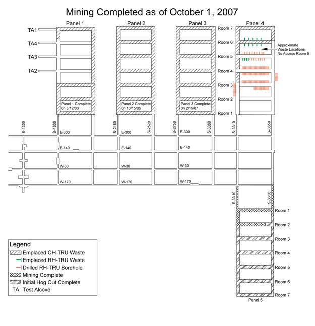
The progress of mining the WIPP underground repository is shown in Figure 15-6. As shown on the figure, as of October 1, 2007, Panels 1 through 4 had been mined completely; Panels 1, 2, and 3 were filled with waste; waste was being emplaced in Panel 4; and mining of Panel 5 was in progress.
Geotechnical analysis reports from 2003 through 2007 show that no major ground control problems or events occurred since the CRA-2004 (U.S. Department of Energy 2004c, 2005b, 2006c, 2007e, and 2008a). As expected, slow deterioration of ground conditions has occurred in the WIPP underground repository as a result of aging, but this has been mitigated by routine maintenance and the implementation of engineered systems, as needed. One incident of minor damage occurred to a catch basin installed in the exhaust shaft to intercept water and prevent it from flowing laterally into the waste shaft sump. The catch basin was originally installed in March 1996; it was damaged by falling debris. A new catch basin was installed in December 2004. This basin was damaged in August 2005, again by debris. The catch basin was replaced by an interception well system between November 2005 and March 2006. The interception well system consists of 4, 30-ft deep, small-diameter holes located in the floor of the drift between the exhaust shaft and the waste shaft. The quantity and quality of fluid entering the system continues to be measured and analyzed. The fluid is routinely removed to prevent drainage into the waste shaft sump.
The original plans for waste emplacement included the placement of remote-handled (RH) transuranic (TRU) (RH-TRU) waste in horizontal boreholes in the walls of waste-emplacement rooms, followed by the emplacement of contact-handled (CH) transuranic (TRU) (CH-TRU) waste in containers in each room. This configuration was planned to be used in all panels in the underground repository. Because CH-TRU waste disposal was approved about six years before RH-TRU waste approval, no RH-TRU waste was emplaced in Panels 1, 2, and 3. RH-TRU waste was emplaced beginning with Panel 4.
Figure 15-6. Status of Mining and Waste Emplacement as of October 1, 2007
On November 15, 2007, the DOE submitted a planned change request to the EPA to use shielded RH-TRU waste containers (Moody 2007) for a portion of RH-TRU waste shipped to the WIPP. The proposed shielded containers, approximately the size of a 55-gallon drum, have 1-in.-thick lead shielding placed between a double-walled steel shell. The external wall is 1/8 in. thick, and the internal wall is 3/16 in. thick. The lid and the bottom of the containers are made of carbon steel and are 3 in. thick. The containers are designed to hold a 30-gallon container, and would be shipped to the WIPP in HalfPACT transportation containers. The surface dose rate would be no higher than 200 millirem/hour.
Use of the shielded containers is proposed to increase efficiency of transportation and operations at the WIPP, as well as at generator sites, because the shielded containers could be managed in the same manner as CH-TRU waste. Record-keeping for RH-TRU waste would not change; containers and waste streams would continue to be designated as RH-TRU waste in the WIPP Waste Information System, and would count against the limit of 5,100,000 curies for RH-TRU waste as specified in the WIPP LWA, as well as the limit of 250,000 ft3 defined by the Consultation and Cooperation Agreement between the DOE and the State of New Mexico.
It is estimated that approximately 27% (Crawford and Taggart 2007) of the RH-TRU waste inventory would be suitable for management in the shielded containers. Higher-activity RH-TRU waste would continue to be managed and emplaced using the current practice.
An analysis of the disposal system performance implications of using the shielded container was performed. The analysis shows that use of shielded containers for candidate waste streams would have an insignificant impact on long-term performance of the disposal system (Dunagan et al. 2007).
Several new research projects have been initiated at the WIPP. Although these projects are not related to the expected performance of the repository, they are described here because they are being performed in the WIPP underground facility. The WIPP underground repository is a desirable location for the experiments because it provides an environment shielded from cosmic radiation that would otherwise interfere with the experiments. Equipment used during these experiments will be removed before closure of the repository.
The Segmented Enriched Germanium Assembly (SEGA) project and the Multiple Element Germanium Array (MEGA) projects are being performed to investigate double-beta decay, a rare type of nuclear decay that provides information on the mass of the neutrino. A modular building for housing the experiments was assembled in the Room Q alcove of the WIPP underground facility in 2003 and 2004. Experiments began in 2005, and preparations began in 2007 for additional studies and experiments in electroforming copper fabricated underground to purify the metal of its natural radioactive contaminants. The SEGA and MEGA projects are being performed by a collaboration of several universities, with Stanford University serving as the lead.
In addition, Los Alamos National Laboratory (LANL) is leading the Enriched Xenon Observatory (EXO) project, also in the WIPP underground repository. This project is investigating neutrinoless double-beta decay. In 2007, several pallets of materials for the experiment were received at WIPP after assembly in California. Setup of the experiments is planned for 2008. The experiments will be performed in the former E-300 shop space between drifts N-1100 and N-1400.
For all of these experiments, the role of the WIPP operator, Washington TRU Solutions, LLC, is to provide support in transporting project materials to the underground facility, health and safety oversight, infrastructure to operate and maintain the experiments, and operational coordination with project researchers.
40 CFR § 194.15(a)(5) requires that the CRA-2009 include “a description of all waste emplaced in the disposal system since the most recent compliance certification or recertification application. Such description shall consist of a description of the waste characteristics and waste components identified in § 194.24(b)(1) and § 194.24(b)(2).” Information responsive to these requirements is provided in the following sections.
The status of waste emplacement in the WIPP underground repository is indicated in Figure 15-6. Additional detail is provided in Section 24, “Waste Characterization.”
Section 24 provides an updated waste inventory of both waste anticipated to be emplaced in the WIPP and waste that has already been emplaced since the CRA-2004. Section 24 also reports an analysis of waste inventory impacts on the performance of the WIPP disposal system. Information about the limits imposed by the DOE on significant components or characteristics of the waste to ensure that they are consistent with assumptions made for the PA is also provided in Section 24.
The inventory for the CRA-2009 PA is the same inventory used for the CRA-2004 PABC. Since the CRA-2004 PABC was completed, the Annual Transuranic Waste Inventory Report–2007 (U.S. Department of Energy 2008c) was published and provides updated inventory information. The DOE anticipates this inventory update will have only a small impact on normalized releases relative to the CRA-2009 PA, and will not be significant for compliance. Therefore, the DOE is in compliance with section 194.24(a) (U.S. Environmental Protection Agency 2004).
40 CFR § 194.15(a)(6) requires the submittal of “any significant information not previously included in a compliance certification or recertification application related to whether the disposal system continues to be in compliance with the disposal regulations.” Information related to this requirement is provided below.
The remainder of this CRA provides the information required by this section of the certification criteria. The DOE believes that this information demonstrates that the WIPP continues to comply with the disposal regulations.
40 CFR § 194.15(a)(7) requires the submittal of “any additional information requested by the Administrator or the Administrator’s authorized representative.” Information related to this requirement is provided below.
There currently are no outstanding requests from the EPA for additional information. As such, the DOE is in compliance with this certification criterion.
40 CFR § 194.15(b) states, “To the extent that information required for a re-certification of compliance remains valid and has been submitted in previous certification or re-certification applications(s), such information need not be duplicated in subsequent applications; such information may be summarized and referenced.” Information related to this requirement is provided below.
The DOE has followed this direction in the preparation of this recertification application. To the extent appropriate, information from the CCA and the CRA-2004 that remains valid and unchanged is not repeated in this recertification application; instead, it is summarized and incorporated by reference.
Beauheim, R.L. 2007. “Diffusivity Mapping of Fracture Interconnections.” Proceedings of the 2007 U.S. EPA/NGWA Fractured Rock Conference (pp. 235–49). Westerville, OH: National Ground Water Association...\..\references\Others\Beauheim_2007_Diffusivity_mapping.pdf
Beauheim, R.L., and R.M. Holt. 1990. “Hydrogeology of the WIPP Site.” Geological and Hydrological Studies of Evaporites in the Northern Delaware Basin for the Waste Isolation Pilot Plant (WIPP), New Mexico (pp. 131–79). Geological Society of America Field Trip No. 14 Guidebook. Dallas: Dallas Geological Society...\..\references\Others\Beauheim_Holt_1990_Hydrogeology_of_the_WIPP_Site.pdf
Crawford, B., and D. Taggart. 2007. Analysis of RH TRU Wastes for Containment in Lead-Shielded Containers (Revision 0). INV-07-08-25-01-01. Carlsbad, NM: Los Alamos National Laboratory-Carlsbad Operations...\..\references\Others\Crawford_Taggart_2007_Analysis_of_RH_TRU_Wastes_for_Containment.pdf
Domski, P.S., and R.L. Beauheim. 2005. Analysis Plan for the Evaluation of Culebra Brine Compositions. AP-125. ERMS 540680. Carlsbad, NM: Sandia National Laboratories...\..\references\Others\Domski_Beauheim_2005_Analysis_Plan_for_the_Evaluation_of_Culebra_Brine_Compositions_ERMS540680.pdf
Dunagan, S.C., G.T. Roselle, E.D. Vugrin, and J.J. Long. 2007. Analysis Report for the Shielded Container Performance Assessment (Revision 1.0). ERMS 547358. Carlsbad, NM: Sandia National Laboratories...\..\references\Others\Dunagan_Roselle_Vugrin_Long_2007_Analysis_Report_for_the_Shielded_Containe_PA_ERMS547358.pdf
Hillesheim, M.B., L.A. Hillesheim, and N.J. Toll. 2007. “Mapping of Pressure-Head Responses of a Fractured Rock Aquifer to Rainfall Events.” Proceedings of the 2007 U.S. EPA/NGWA Fractured Rock Conference (pp. 522–36). Westerville, OH: National Ground Water Association...\..\references\Others\Hillesheim_et_al_2007_Mapping_of_Pressure_Head.pdf
Holt, R.M., and L. Yarbrough. 2002. Analysis Report: Task 2 of AP-088; Estimating Base Transmissivity Fields (July 8). ERMS 523889. Carlsbad, NM: Sandia National Laboratories...\..\references\Others\Holt_Yarbrough_2002_Analysis_Report_Task_2_of_AP_088_Estimating_Base_TFIELDs_ERMS523889.pdf
Holt, R.M., R.L. Beauheim, and D.W. Powers. 2005. “Predicting Fractured Zones in the Culebra Dolomite.” Dynamics of Fluids and Transport in Fractured Rock (pp. 103–16). B. Faybishenko, P.A. Witherspoon, and J. Gale, eds. Geophysical Monograph Series 162. Washington, DC: American Geophysical Union...\..\references\Others\Holt_Beauheim_Powers_2005_Predicting_Fractured_Zones.pdf
Lorenz, J.C. 2006a. Assessment of the Potential for Karst in the Rustler Formation at the WIPP Site. SAND2005-7303. Albuquerque: Sandia National Laboratories...\..\references\Others\Lorenz_2006_Assessment_of_Potential_for_Karst_SAND2005_7303.pdf
Lorenz, J.C. 2006b. “Assessment of the Geological Evidence for Karst in the Rustler Formation at the WIPP Site.” Caves and Karst of Southeastern New Mexico (pp. 243–52). L. Land, V.W. Lueth, W. Raatz, P. Boston, and D.L. Love, eds. 57th Annual Fall Field Conference Guidebook. Socorro, NM: New Mexico Geological Society...\..\references\Others\Lorenz_2006_Geo_Evidence_for_Karst.pdf
Lowry, T.S., and R.L. Beauheim. 2004. Analysis Report: Task 2 of AP-110; Evaluation of Water-Level Rise in the Culebra Due to Recharge from Refining Process Water Discharged onto Potash Tailings Piles. ERMS 536239. Carlsbad, NM: Sandia National Laboratories...\..\references\Others\Lowry_Beauheim_2004_Analysis_Report_Task_2_of_AP110_ERMS536239.pdf
Lowry, T.S., and R.L. Beauheim. 2005. Analysis Report: Task 3 of AP-110; Evaluation of Water-Level Rise in the Culebra Due to Leakage through Poorly Plugged and Abandoned Potash Boreholes. ERMS 540187. Carlsbad, NM: Sandia National Laboratories...\..\references\Others\Lowry_Beauheim_2005_Analysis_Report_Task_3_of_AP110_ERMS540187.pdf
McKenna, S.A. 2004. Analysis Report: Culebra Water Level Monitoring Network Design. AP-111. ERMS 540477. Carlsbad, NM: Sandia National Laboratories...\..\references\Others\McKenna_2004_Analysis_Report_Culebra_Water_Level_Monitoring_AP111_ERMS540477.pdf
Moody, D.C. 2007. Letter to J. Reyes (Subject: Transmittal of Planned Change Request for Shielded Containers). 15 November 2007. U.S. Department of Energy, Carlsbad Field Office, Carlsbad, NM...\..\references\Others\Moody_to_Reyes_2007_November_15_Shielded_Contaners_Change_Request.pdf
Powers, D.W. 2002. Analysis Report: Task 1 of AP-088; Construction of Geologic Contour Maps (April 17). ERMS 522086. Carlsbad, NM: Sandia National Laboratories...\..\references\Others\Powers_2002_Analysis_Report_Task_1_of_AP088_ERMS522086.pdf
Powers, D.W. 2006a. Analysis Report: Task 1D of AP-114; Collect Current and Historic Information on Water Levels and Specific Gravity in Potash Tailings Ponds within the Culebra Modeling Domain (March 31). ERMS 543124. Carlsbad, NM: Sandia National Laboratories...\..\references\Others\Powers_2006_Analysis_Report_for_Task_1D_AP114_ERMS543124.pdf
Powers, D.W. 2006b. Analysis Report: Task 1B of AP-114; Identify Possible Area of Recharge to the Culebra West and South of WIPP (April 1). ERMS 543094. Carlsbad, NM: Sandia National Laboratories...\..\references\Others\Powers_2006_Analysis_Report_for_Task_1B_AP114_ERMS543094.pdf
Powers, D.W. 2007. Analysis Report for Task 1A of AP-114: Refinement of Rustler Halite Margins within the Culebra Modeling Domain (October 5). ERMS 547559. Carlsbad, NM: Sandia National Laboratories...\..\references\Others\Powers_2007_Analysis_Report_for_Task_1A_AP114_ERMS547559.pdf
Powers, D., R. Beauheim, R. Holt, and D. Hughes. 2006. “Evaporite Karst Features and Processes at Nash Draw, Eddy County, New Mexico.” Caves and Karst of Southeastern New Mexico (pp. 253–66). L. Land, V.W. Lueth, W. Raatz, P. Boston, and D.L. Love, eds. 57th Annual Fall Field Conference Guidebook. Socorro, NM: New Mexico Geological Society...\..\references\Others\Powers_et_al_2006_Evaporite_karst.pdf
Roberts, R.M. 2006. Analysis Report for AP-070: Analysis of Culebra Pumping Tests Performed between December 2003 and August 2005. ERMS 543901. Carlsbad, NM: Sandia National Laboratories...\..\references\Others\Roberts_2006_Culebra_Analysis_Report_December_2003_to_August_2005_ERMS543901.pdf
Roberts, R.M. 2007. Analysis Report for AP-070: Analysis of Culebra Hydraulic Tests Performed between June 2006 and September 2007. ERMS 547418. Carlsbad, NM: Sandia National Laboratories...\..\references\Others\Roberts_2007_Culebra_Analysis_Report_June_2006_to_September_2007_ERMS547418.pdf
Sandia National Laboratories (SNL). 2008. Sandia National Laboratories Compliance Monitoring Parameter Assessment for 2007 (January). ERMS 548041. Carlsbad, NM: Sandia National Laboratories...\..\references\Others\Wagner_Hillesheim_2008_Annual_Compliance_Monitoring_Parameter_Assessment_2007_ERMS548041.pdf
Siegel, M.D., S.J. Lambert, and K.L. Robinson, eds. 1991. Hydrochemical Studies of the Rustler Formation and Related Rocks in the Waste Isolation Pilot Plant Area, Southeastern New Mexico. SAND88-0196. ERMS 225624. Albuquerque: Sandia National Laboratories...\..\references\Others\Siegel_Lambert_Robinson_1991_Hydrochemical_Studies_of_the_Rustler_Formation_SAND88_0196.pdf
U.S. Department of Energy (DOE). 1996. Title 40 CFR Part 191 Compliance Certification Application for the Waste Isolation Pilot Plant (October). 21 vols. DOE/CAO 1996-2184. Carlsbad, NM: Carlsbad Area Office...\..\references\CCA\CCA.htm
U.S. Department of Energy (DOE). 2003. Waste Isolation Pilot Plant Site Environmental Report: Calendar Year 2002 (Rev. 1, September). DOE/WIPP 03-2225. Carlsbad, NM: Carlsbad Field Office...\..\references\Others\DOE_WIPP_Environmental_Report_03_2225.pdf
U.S. Department of Energy (DOE). 2004a. Title 40 CFR Part 191 Compliance Recertification Application for the Waste Isolation Pilot Plant (March). 10 vols. DOE/WIPP 2004-3231. Carlsbad, NM: Carlsbad Field Office...\..\references\CRA-2004\CRA-2004.htm
U.S. Department of Energy (DOE). 2004b. Waste Isolation Pilot Plant 2003 Site Environmental Report. DOE/WIPP 04-2225. Carlsbad, NM: Carlsbad Field Office...\..\references\Others\DOE_WIPP_Environmental_Report_04_2225.pdf
U.S. Department of Energy (DOE). 2004c. Geotechnical Analysis Report for July 2002–June 2003 (March). 2 vols. DOE/WIPP 04-3177. Carlsbad, NM: Carlsbad Field Office...\..\references\Others\DOE_Geotechnical_Analysis_Report_04_3177.pdf
U.S. Department of Energy (DOE). 2005a. Waste Isolation Pilot Plant 2004 Site Environmental Report. DOE/WIPP 05-2225. Carlsbad, NM: Carlsbad Field Office...\..\references\Others\DOE_WIPP_Environmental_Report_05_2225.pdf
U.S. Department of Energy (DOE). 2005b. Geotechnical Analysis Report for July 2003–June 2004 (March; vol. 1). DOE/WIPP 05-3177. Carlsbad, NM: Carlsbad Field Office...\..\references\Others\DOE_Geotechnical_Analysis_Report_05_3177.pdf
U.S. Department of Energy (DOE). 2006a. Waste Isolation Pilot Plant Biennial Environmental Compliance Report. DOE/WIPP 06-2171. Carlsbad, NM: Carlsbad Field Office...\..\references\Others\DOE_WIPP_Biennial_Environmental_Compliance_Report_WIPP06_2171.pdf
U.S. Department of Energy (DOE). 2006b. Waste Isolation Pilot Plant Annual Site Environmental Report for 2005 (September). DOE/WIPP 06-2225. Carlsbad, NM: Carlsbad Field Office...\..\references\Others\DOE_WIPP_Environmental_Report_06_2225.pdf
U.S. Department of Energy (DOE). 2006c. Geotechnical Analysis Report for July 2004–June 2005 (April). 2 vols. DOE/WIPP 06-3177. Carlsbad, NM: Carlsbad Field Office...\..\references\Others\DOE_Geotechnical_Analysis_Report_06_3177.pdf
U.S. Department of Energy (DOE). 2006d. WIPPSubsidence MonumentLeveling Survey 2006 (December 2006). DOE/WIPP 07-2293. Carlsbad, NM: Carlsbad Field Office...\..\references\Others\DOE_Subsidence_07_2293.pdf
U.S. Department of Energy (DOE). 2007a. Waste Isolation Pilot Plant Annual Site Environmental Report for 2006 (September). DOE/WIPP 07-2225. Carlsbad, NM: Carlsbad Field Office...\..\references\Others\DOE_WIPP_Environmental_Report_07_2225.pdf
U.S. Department of Energy (DOE). 2007b. Annual Change Report 2006/2007: From July 1, 2006, to June 30, 2007 (November 16). DOE/WIPP 07-3317. Carlsbad, NM: Carlsbad Field Office...\..\references\Others\DOE_Annual_Change_Report_2006_2007_07_3317.pdf
U.S. Department of Energy (DOE). 2007c. Delaware Basin Monitoring Annual Report (September). DOE/WIPP 07-2308. Carlsbad, NM: Carlsbad Field Office...\..\references\Others\DOE_Delaware_Basin_Annual_Report_07_2308.pdf
U.S. Department of Energy (DOE). 2007d. Geotechnical Analysis Report for July 2005–June 2006 (March; vol. 1). DOE/WIPP 07-3177. Carlsbad, NM: Carlsbad Field Office...\..\references\Others\DOE_Geotechnical_Analysis_Report_07_3177.pdf
U.S. Department of Energy (DOE). 2008a. Geotechnical Analysis Report for July 2006–June 2007 (March). 2 vols. DOE/WIPP 08-3177. Carlsbad, NM: Carlsbad Field Office...\..\references\Others\DOE_Geotechnical_Analysis_Report_08_3177.pdf
U.S. Department of Energy (DOE). 2008b. Basic Data Report for Piezometers PZ-13, PZ-14, and PZ-15 and Shallow Subsurface Water (Revision 1, April). DOE/WIPP 08-3375. Carlsbad, NM: Carlsbad Field Office...\..\references\Others\DOE_Shallow_Subsurface_Water_08_3375.pdf
U.S. Department of Energy (DOE). 2008c. Annual Transuranic Waste Inventory Report—2007 (Revision 1). DOE/TRU 2008-3379. Carlsbad, NM: Carlsbad Field Office...\..\references\Others\DOE_2008_Annual_TRU_Waste_Inventory_Report_2007_Main_Body_and_Appendices_2008_3379.pdf
U.S. Environmental Protection Agency (EPA). 1996. “40 CFR Part 194: Criteria for the Certification and Recertification of the Waste Isolation Pilot Plant’s Compliance with the 40 CFR Part 191 Disposal Regulations; Final Rule.” Federal Register, vol. 61 (February 9, 1996): 5223–45...\..\references\Others\EPA_61_FR_5224_5245_February_9_1996.pdf
U.S. Environmental Protection Agency (EPA). 1998a. “CARD No. 14: Content of Compliance Certification Application.” Compliance Application Review Documents for the Criteria for the Certification and Recertification of the Waste Isolation Pilot Plant’s Compliance with the 40 CFR Part 191 Disposal Regulations: Final Certification Decision (May) (pp. 14-1 through 14-86). Washington, DC: Office of Radiation and Indoor Air...\..\references\Others\EPA_CCA_CARD_14.pdf
U.S. Environmental Protection Agency (EPA). 1998b. “40 CFR Part 194: Criteria for the Certification and Recertification of the Waste Isolation Pilot Plant’s Compliance with the Disposal Regulations: Certification Decision; Final Rule.” Federal Register, vol. 63 (May 18, 1998): 27353–406...\..\references\Others\EPA_63_FR_27353_408_May_18_1998.pdf
U.S. Environmental Protection Agency (EPA). 2004. “40 CFR Part 194: Criteria for the Certification and Recertification of the Waste Isolation Pilot Plant’s Compliance with the Disposal Regulations; Alternative Provisions” (Final Rule). Federal Register, vol. 69 (July 16, 2004): 42571–583...\..\references\Others\EPA_69_FR_42571_83_July_16_2004.pdf
U.S. Environmental Protection Agency (EPA). 2006a. “Recertification CARD Nos. 14/15: Content of Compliance Certification Application and Compliance Recertification Application(s).” Compliance Application Review Documents for the Criteria for the Certification and Recertification of the Waste Isolation Pilot Plant’s Compliance with the 40 CFR Part 191 Disposal Regulations: Final Recertification Decision (March) (pp. 14/15-1 through 14/15-34, pp. 14-A-1 through 14-A-3, and pp. 15-A-1 through 15-A-17). Washington, DC: Office of Radiation and Indoor Air...\..\references\Others\EPA_CRA_CARD_14_15.pdf
U.S. Environmental Protection Agency (EPA). 2006b. “40 CFR Part 194: Criteria for the Certification and Recertification of the Waste Isolation Pilot Plant’s Compliance with the Disposal Regulations: Recertification Decision” (Final Notice). Federal Register, vol. 71 (April 10, 2006): 18010–021...\..\references\Others\EPA_71_FR_18010_18021_April_10_2006.pdf